![]()
| This page uses Creative Commons Licensed content from Wikipedia (view authors). |
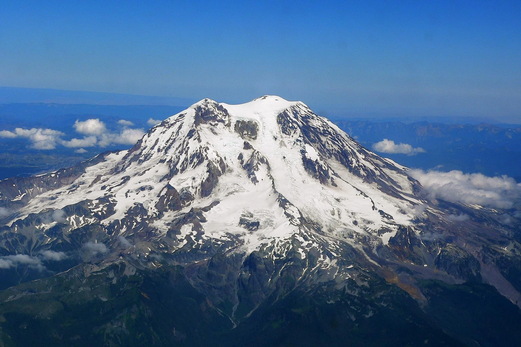
| Mt. Rainier | |
|---|---|
| |
| Mount Rainier | |
| Type | stratovolcano |
| Elevation | 14,411 ft (4,392 m) |
| Volcanic Region | Cascades |
| Current Status | |
| Last Eruption | 1894 |
Mount Rainier is a massive stratovolcano located 54 miles (87 km) southeast of Seattle in the state of Washington, United States. It is the most topographically prominent mountain in the contiguous United States and the Cascade Volcanic Arc, with a summit elevation of 14,411 ft (4,392 m). Mt. Rainier is considered one of the most dangerous volcanoes in the world, and it is on the Decade Volcano list. Because of its large amount of glacial ice, Mt. Rainier could potentially produce massive lahars that would threaten the whole Puyallup River valley.
Geographical setting[]
Mount Rainier is the highest mountain in Washington and the Cascade Range. Mount Rainier has a topographic prominence of 13,211 ft (4,027 m), greater than K2 at 13,189 ft (4,020 m). On clear days it dominates the southeastern horizon in most of the Seattle-Tacoma metropolitan area to such an extent that locals sometimes refer to it simply as "the Mountain." On days of exceptional clarity, it can also be seen from as far away as Portland, Oregon and Victoria, British Columbia.
With 26 major glaciers and 36 sq mi (93 km2) of permanent snowfields and glaciers, Mount Rainier is the most heavily glaciated peak in the lower 48 states. The summit is topped by two volcanic craters, each more than 1,000 ft (300 m) in diameter with the larger east crater overlapping the west crater. Geothermal heat from the volcano keeps areas of both crater rims free of snow and ice, and has formed the world's largest volcanic glacier cave network within the ice-filled craters, with nearly 2 mi (3.2 km) of passages. A small crater lake about 130 by 30 ft (40 by 9.1 m) in size and 16 ft (5 m) deep, the highest in North America with a surface elevation of 14,203 ft (4,329 m), occupies the lowest portion of the west crater below more than 100 ft (30 m) of ice and is accessible only via the caves.
The Carbon, Puyallup, Mowich, Nisqually, and Cowlitz Rivers begin at eponymous glaciers of Mount Rainier. The sources of the White River are Winthrop, Emmons, and Fryingpan Glaciers. The White, Carbon, and Mowich join the Puyallup River, which discharges into Commencement Bay at Tacoma; the Nisqually empties into Puget Sound east of Lacey; and the Cowlitz joins the Columbia River between Kelso and Longview.
Subsidiary peaks[]
The broad top of Mount Rainier contains three named summits. The highest is called the Columbia Crest. The second highest summit is Point Success, 14,158 ft (4,315 m), at the southern edge of the summit plateau, atop the ridge known as Success Cleaver. It has a topographic prominence of about 138 ft (42 m), so it is not considered a separate peak. The lowest of the three summits is Liberty Cap, 14,112 ft (4,301 m), at the northwestern edge, which overlooks Liberty Ridge, the Sunset Amphitheater, and the dramatic Willis Wall. Liberty Cap has a prominence of 492 ft (150 m), and so would qualify as a separate peak under most of strictly prominence-based rules. A prominence cutoff of 400 ft (122 m) is commonly used in Washington state.
High on the eastern flank of Mount Rainier is a peak known as Little Tahoma Peak, 11,138 ft (3,395 m), an eroded remnant of the earlier, much higher, Mount Rainier. It has a prominence of 858 ft (262 m), and it is almost never climbed in direct conjunction with Columbia Crest, so it is usually considered a separate peak. If considered separately from Mt. Rainier, Little Tahoma Peak would be the third highest mountain peak in Washington.
Mount Rainier is a stratovolcano in the Cascade Volcanic Arc. Its early lava deposits are estimated at more than 840,000 years old and are part of the Lily Formation (about 2.9 million to 840,000 years ago). The early deposits formed a "proto-Rainier" or an ancestral cone prior to the present-day cone. The present cone is more than 500,000 years old.
The volcano is highly eroded, with glaciers on its slopes, and appears to be made mostly of andesite. Rainier likely once stood even higher than today at about 16,000 ft (4,900 m) before a major debris avalanche and the resulting Osceola Mudflow approximately 5,000 years ago. In the past, Rainier has had large debris avalanches, and has also produced enormous lahars (volcanic mudflows) due to the large amount of glacial ice present. Its lahars have reached all the way to Puget Sound, a distance of more than 30 mi (48 km). Around 5,000 years ago, a large chunk of the volcano slid away and that debris avalanche helped to produce the massive Osceola Mudflow, which went all the way to the site of present-day Tacoma and south Seattle. This massive avalanche of rock and ice removed the top 1,600 ft (500 m) of Rainier, bringing its height down to around 14,100 ft (4,300 m). About 530 to 550 years ago, the Electron Mudflow occurred, although this was not as large-scale as the Osceola Mudflow.
After the major collapse approximately 5,000 years ago, subsequent eruptions of lava and tephra built up the modern summit cone until about as recently as 1,000 years ago. As many as 11 Holocene tephra layers have been found.
Modern activity and the current threat[]
Mount Rainier is one of the 16 Decade Volcanoes. The most recent recorded volcanic eruption was between 1820 and 1854, but many eyewitnesses reported eruptive activity in 1858, 1870, 1879, 1882 and 1894 as well.
Although Mount Rainier is an active volcano, as of 2010 there was no evidence of an imminent eruption. However, an eruption could be devastating for all areas surrounding the volcano. Mount Rainier is currently listed as a Decade Volcano, or one of the 16 volcanoes with the greatest likelihood of causing great loss of life and property if eruptive activity resumes. If Mt. Rainier were to erupt as powerfully as Mount St. Helens did in its May 18, 1980 eruption, the effect would be cumulatively greater, because of the far more massive amounts of glacial ice locked on the volcano compared to Mount St. Helens and the vastly more heavily populated areas surrounding Rainier. Lahars from Rainier pose the most risk to life and property, as many communities lie atop older lahar deposits. According to USGS, about 150,000 people live on top of old lahar deposits of Rainier. Not only is there much ice atop the volcano, the volcano is also slowly being weakened by hydrothermal activity. According to Geoff Clayton, a geologist with a Washington State Geology firm, RH2 Engineering, a repeat of the Osceola mudflow would destroy Enumclaw, Orting, Kent, Auburn, Puyallup, Sumner and all of Renton. Such a mudflow might also reach down the Duwamish estuary and destroy parts of downtown Seattle, and cause tsunamis in Puget Sound and Lake Washington. Another Cascade Arc volcano with similar hazards is Mount Meager in southwestern British Columbia, Canada, which has produced several large landslides in the past 8,000 years, as well as an eruption 2,350 years ago that was similar in size to Mount St. Helens' 1980 eruption. Rainier is also capable of producing pyroclastic flows and lava.
According to K. Scott, a scientist with the USGS: "A home built in any of the probabilistically defined inundation areas on the new maps is more likely to be damaged or destroyed by a lahar than by fire...For example, a home built in an area that would be inundated every 100 years, on the average, is 27 times more likely to be damaged or destroyed by a flow than by fire. People know the danger of fire, so they buy fire insurance and they have smoke alarms, but most people are not aware of the risks of lahars, and few have applicable flood insurance."
The volcanic risk is somewhat mitigated by lahar warning sirens and escape route signs in Pierce County. The more populous King County is also in the Lahar area, but currently has no zoning restrictions due to volcanic hazard. More recently (since 2001) funding from the federal government for lahar protection in the area has dried up, leading local authorities in at-risk cities like Orting to fear a disaster similar to the Armero tragedy.
Seismic background[]
Typically, up to five earthquakes are recorded monthly near the summit. Swarms of five to ten shallow earthquakes over two or three days take place from time to time, predominantly in the region of 13,000 feet (4 km) below the summit. These earthquakes are thought to be caused by the circulation of hot fluids beneath Mount Rainier. Presumably, hot springs and steam vents within Mount Rainier National Park are generated by such fluids. Seismic swarms (not initiated with a mainshock) are common features at volcanoes, and are rarely associated with eruptive activity. Rainier has had several such swarms; there were days-long swarms in 2002, 2004, and 2007, two of which (2002 and 2004) included M 3.2 earthquakes. A 2009 swarm produced the largest number of events of any swarm at Rainier since seismic monitoring began over two decades earlier. Yet another swarm was observed in 2011.
Glaciers[]
Three-dimensional representation of Mount Rainier Glaciers are among the most conspicuous and dynamic geologic features on Mount Rainier. They erode the volcanic cone and are important sources of streamflow for several rivers, including some that provide water for hydroelectric power and irrigation. Together with perennial snow patches, the 26 major glaciers cover about 36 square miles (93 km2) of the mountain's surface and have a volume of about 1 cubic mile (4.2 km3).
Glaciers flow under the influence of gravity by the combined action of sliding over the rock on which they lie and by deformation, the gradual displacement between and within individual ice crystals. Maximum speeds occur near the surface and along the centerline of the glacier. During May 1970, Nisqually Glacier was measured moving as fast as 29 inches (74 cm) per day. Flow rates are generally greater in summer than in winter, probably due to the presence of large quantities of meltwater at the glacier base.
The size of glaciers on Mount Rainier has fluctuated significantly in the past. For example, during the last ice age, from about 25,000 to about 15,000 years ago, glaciers covered most of the area now within the boundaries of Mount Rainier National Park and extended to the perimeter of the present Puget Sound Basin. Between the 14th century and 1850, many of the glaciers on Mount Rainier advanced to their farthest extent downvalley since the last ice age. Many advances of this sort occurred worldwide during this time period known to geologists as the Little Ice Age. During the Little Ice Age, the Nisqually Glacier advanced to a position 650 to 800 ft (200 to 240 m) downvalley from the site of the Glacier Bridge, Tahoma and South Tahoma Glaciers merged at the base of Glacier Island, and the terminus of Emmons Glacier reached within 1.2 mi (1.9 km) of the White River Campground. Retreat of the Little Ice Age glaciers was slow until about 1920 when retreat became more rapid. Between the height of the Little Ice Age and 1950, Mount Rainier's glaciers lost about one-quarter of their length. Beginning in 1950 and continuing through the early 1980s, however, many of the major glaciers advanced in response to relatively cooler temperatures of the mid-century. The Carbon, Cowlitz, Emmons, and Nisqually Glaciers advanced during the late 1970s and early 1980s as a result of high snowfalls during the 1960s and 1970s. Since the early-1980s, however, many glaciers have been thinning and retreating and some advances have slowed.
Current Volcanic Status[]
Current Status: ![]()
Last Eruption: 1894
Current Activity Information: The Mt. Rainier volcano is currently undergoing a state of slumber. No unusual activity is present.